Technological advancements in spatial digitization revolutionize geometric surveying by improving accuracy, efficiency, real-time data collection, and analysis, enabling precise mapping, better decision-making, and enhanced project management in various industries.

The intelligent GIS-driven system enhances property and tax administration through advanced geospatial surveying, ensuring accurate mapping, efficient data management, real-time analysis, and improved decision-making for streamlined urban planning and revenue management.

Geospatial intelligence revolutionizes industries by enhancing surveying accuracy, optimizing data collection, enabling real-time analysis, and improving decision-making, leading to smarter urban planning, efficient resource management, and streamlined infrastructure development.

Our innovative geospatial and engineering solutions enhance geometric surveying across industries, ensuring precise mapping, efficient data analysis, improved decision-making, and optimized resource management for smarter infrastructure, urban planning, and sustainable development.

The AI-driven Pan-India digital agronomy framework enables hyperlocal crop monitoring, utilizing advanced geospatial technologies to enhance agricultural practices, improve crop yield prediction, optimize resource usage, and support sustainable farming practices.


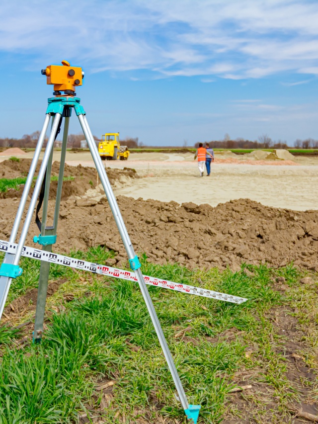
Leveraging Data-Driven Geospatial Solutions: Shaping the Future of Geometric Surveying
Leveraging data-driven geospatial solutions is transforming the future of geometric surveying by enhancing precision, efficiency, and scalability. With advanced technologies like GIS, AI, and machine learning, surveying processes are becoming more automated, allowing for real-time data analysis and decision-making. These innovations enable the creation of intelligent, accurate assets that streamline the planning, management, and execution of complex projects. By integrating geospatial intelligence into surveying practices, industries can optimize resource allocation, reduce operational costs, and improve sustainability.
GeoMetric Survey: Your Trusted and Unmatched GIS Services Partner
GeoMetric Survey strives to be your trusted and unmatched GIS services partner, offering cutting-edge solutions for all your geospatial needs. Specializing in accurate data collection, advanced mapping, and real-time analysis, we provide tailored GIS services for industries ranging from urban planning to environmental monitoring. Our expertise ensures precise, actionable insights that empower better decision-making, optimized resource management, and sustainable project outcomes. With a commitment to innovation and quality, we deliver solutions that integrate seamlessly into your operations, helping you harness the full potential of geospatial intelligence. Trust us to elevate your projects with our expert GIS services.

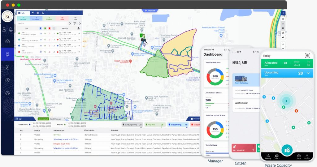
Advanced Waste Collection
Tracking Platform
Services We Offer

Spatial data engineering
Spatial data engineering in geometric surveys ensures precise mapping, analysis, and decision-making for various industries.
Mapping
Mapping in geometric surveying enhances accuracy, spatial analysis, and decision-making for efficient land and infrastructure management.

Surveying
Surveying in geometric surveys ensures precise data collection, mapping, and analysis for informed decision-making and
planning.
Our Core Industries
Of Focus

Municipality
Municipalities conduct GeoMetric Survey for urban planning, land mapping, infrastructure development, zoning regulations, environmental assessment, and
resource management efficiently.

Utilities & Telecommunication
GeoMetric Survey assist utilities and telecommunication in network planning, infrastructure mapping, maintenance, and service optimization.

Smart Cities
GeoMetric Survey support smart cities by enabling accurate mapping, infrastructure planning, efficient transportation, resource management, environmental
monitoring, and sustainable urbandevelopment.

Construction
GeoMetric Survey in construction ensure accurate land mapping, foundation planning, structural alignment, grading,
safety compliance, and
efficient project
execution.

Roads & Highways
GeoMetric Survey for roads and
highways provide accurate mapping, alignment, grading, drainage
planning, land acquisition,
safety analysis, and construction
optimization.
Oil & Gas
GeoMetric Survey in oil and
gas support exploration, pipeline
design, site assessment, resource
mapping, safety, environmental
compliance, and infrastructure
development.
Land Records
System
GeoMetric Survey ensure accurate land records, boundary mapping, ownership verification, and efficient land management systems.

Calibrate
Calibration in GeoMetric Survey is a critical process to ensure the precision and accuracy of survey instruments, such as total stations, GPS receivers, and laser scanners. By regularly calibrating these devices, discrepancies in measurements are corrected, leading to reliable data collection. This process is essential for producing accurate maps, designs, and layouts for construction, infrastructure, and land development projects. Proper calibration also minimizes errors, ensuring compliance with industry standards and improving overall efficiency in various sectors like construction, oil and gas, and urban planning.
Allocate
Allocation in GeoMetric Survey involves assigning resources, equipment, and personnel to specific survey tasks to ensure accurate data collection and efficient project execution. Proper allocation helps optimize surveying efforts in construction, urban planning, oil and gas, and infrastructure development. It includes designating land parcels, mapping coordinates, and distributing workload among survey teams. Effective resource allocation ensures precise measurements, minimizes errors, and enhances project efficiency. This process is essential for accurate land mapping, boundary determination, and infrastructure planning, supporting sustainable development and regulatory compliance.


Sweep
Sweeping in GeoMetric Survey refers to systematically scanning and measuring land or structures using advanced surveying instruments like LiDAR, GPS, and total stations. This process ensures comprehensive data collection for terrain mapping, infrastructure planning, and construction projects. Sweeping techniques help detect irregularities, assess land conditions, and improve accuracy in boundary determination. It is crucial for large-scale projects, including roads, highways, smart cities, and oil and gas exploration, ensuring precise measurements, minimizing errors, and optimizing project efficiency for sustainable development and regulatory compliance.
Curate
Curating in GeoMetric Survey involves collecting, organizing, and analyzing spatial data to ensure accuracy and usability for various projects. This process includes validating survey measurements, refining data sets, and integrating relevant geographic information for construction, urban planning, and infrastructure development. Proper curation enhances decision-making by providing reliable and structured survey data. It supports mapping, boundary determination, and land management, ensuring compliance with industry standards. Effective curation optimizes project efficiency, reduces errors, and enhances the quality of survey outcomes for sustainable development and planning.